
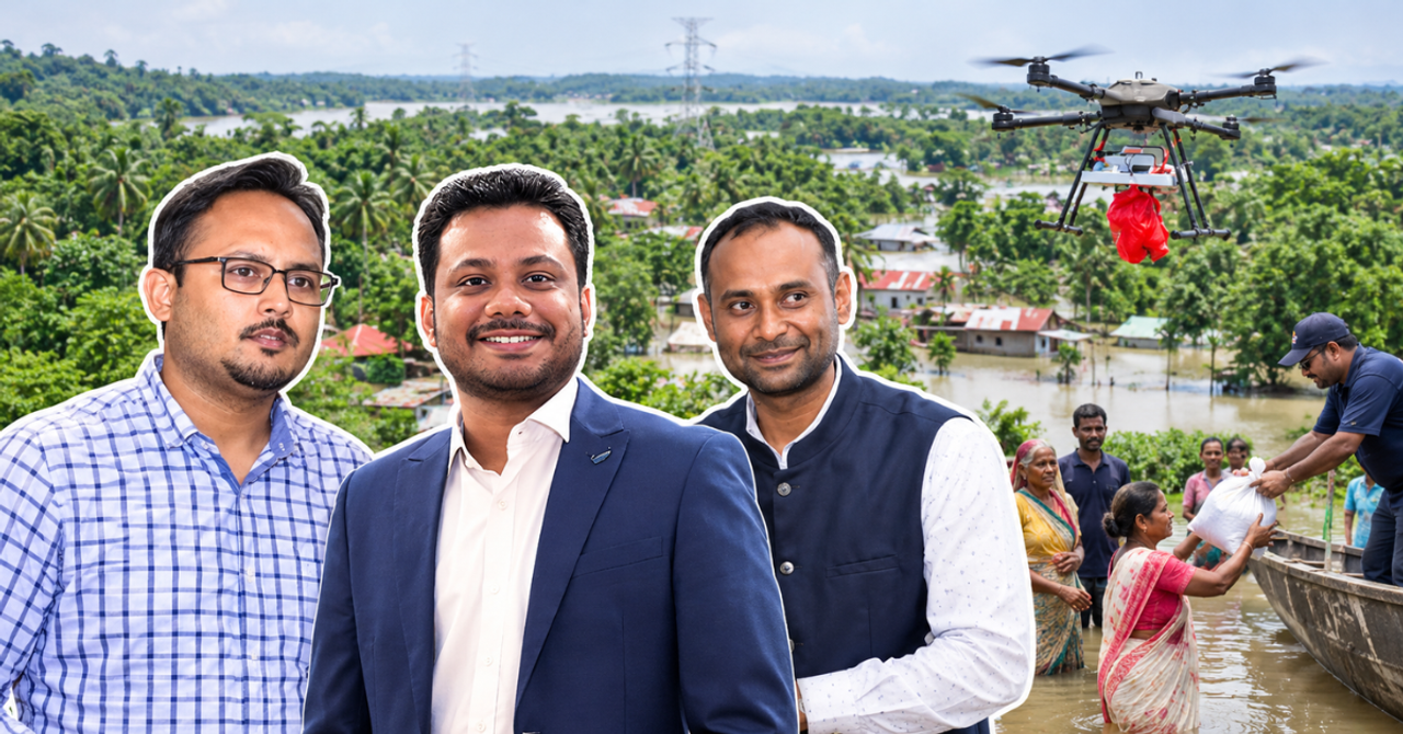
“People, animals, agricultural fields – everything has been severely affected,” says Dakshina, a resident of Nazira in Assam who witnessed the floods. “There were no roads, no bridges, and no accessible routes because everything was submerged in water.”
When floodwaters swallow roads, cover bridges and surround entire settlements, getting help to people becomes a race against time. In Assam, where communities face recurring floods, even getting essential supplies to stranded residents can become a challenge.
During the recent floods in Upper Assam, parts of Sivasagar and other affected districts faced precisely this problem. Water had cut off communities from the road network, and in some places, even boats struggled to reach people because the water was too shallow.
For residents, the uncertainty was frightening. People had to find safer ground while trying to save their livestock and livelihoods. Some were stranded in places where rescue teams could not easily reach them.
In this situation, Drones Tech Lab, a deep-tech company incubated at the Indian Institute of Technology (IIT) Guwahati, deployed payload-carrying drones to deliver food, water, medicines and other essentials across three districts in Assam. The operation reached more than 1,000 people in locations where even conventional relief efforts faced access constraints.
The drones also helped survey affected areas and identify stranded residents, giving relief and rescue teams a clearer picture of where assistance was needed.
For Dakshina, the intervention revealed a side of drone technology she had never seen before.

“Usually, we know drones as something used for taking videos at parties, weddings, or similar events,” she says. “But this time, we saw for the first time how drones can actually help people during a disaster.”
Behind this intervention was technology that had taken years to develop, test and adapt for India's challenging terrain.
‘We wanted India to build its own drones’
Founded in 2016 by Ritesh Kanu, Biswajit Dey and Debajit Deka, Drones Tech Lab began with a vision to develop indigenous drone capabilities in a country that relied heavily on foreign technology.
At the time, India's drone ecosystem was still taking shape. Awareness of its applications beyond photography was limited, access to funding was difficult, and building hardware-intensive technology came with significant challenges.
Kanu says the founders wanted to address the dependence on imported systems and build technology suited to India's operational needs.
“India has been a consumer of drone technology right from the start,” he says. “We had a belief and a vision that we should be building in assets.”
For the team, indigenous technology did not mean manufacturing every component locally from day one. It meant developing intellectual property, designing system architecture, integrating software and engineering drones for specific missions.
Their early work was influenced by the challenges faced by defence personnel operating in difficult environments. The founders saw how technology could help reduce risks to human life, particularly when information about a location or threat was difficult to obtain.
Through its association with IIT Guwahati, the company developed unmanned aerial vehicles (UAVs), flight systems, software and specialised payload mechanisms.

One of its developments was a heavy-payload drone with an indigenous carbon-fibre frame capable of carrying up to 30 kg. The company has since worked across disaster response, defence, healthcare logistics, mapping, conservation and infrastructure.
Kanu compares a drone's carbon-fibre frame to a car's chassis: it holds the different components together. Its propulsion system, which includes motors and electronic speed controllers, provides the force needed to lift and move the drone.
The real capability, however, lies in how these components work together. By modifying software, propulsion systems and payload-release mechanisms, the team can adapt a drone to the requirements of a particular mission.
During a flood, that could mean carrying essential supplies to a settlement cut off by water.
A drone can take help to floot-hit villages
The first challenge during a flood is understanding what is happening on the ground. Which settlements are cut off? Where are people stranded? Which areas need supplies most urgently? And how can rescue teams approach them safely?
Drones can survey affected areas from above, helping teams map isolated pockets and prioritise their response. Once a delivery point is identified, its coordinates can be entered into the flight plan. The drone then carries the supplies to the designated location, where the package is released for people on the ground to collect.
During the Assam operation, Drones Tech Lab used drones with a payload capacity of around 5 kg per flight. They travelled approximately 5 km on missions that took about 25 minutes.
The smaller payload was a deliberate choice based on the conditions.
“We have drones that can carry more than 50 kilos also,” says Kanu. “But the situation demanded a drone with a payload capacity of around 5 kg to make the operation more effective.”
The process involved much more than flying an aircraft. The team mapped affected locations, coordinated with government officials, prepared supply packets and identified suitable delivery points. Local authorities helped the team reach launch locations and coordinate its work with relief efforts.

Together, these steps helped the team plan where supplies needed to go and how to get them there.
Drones also helped responders understand the condition of stranded residents. Dakshina recalls how aerial surveys identified people on rooftops or trapped alongside their livestock, while providing information about water levels and possible routes for rescue teams.
When immediate physical rescue was not possible, aerial assessments helped teams determine whether people had food and water and needed urgent assistance.
Every disaster taught them something new
The company had already deployed its technology during the 2022 Assam floods and following Cyclone Amphan in West Bengal's Sundarbans.
Each operation offered lessons in mapping affected areas, locating stranded communities and improving the software used to plan missions.
“It's not just a camera drone being flown and then dropping food material somewhere,” says Kanu. “The most important thing is that it has to be effective, and that comes only when you have the data.”

He explains that repeated field deployments have helped the team improve how it analyses affected areas and identifies locations that should be prioritised. The goal is to reduce the time between identifying a need and delivering assistance.
The company's work extends beyond floods, too. Drones Tech Lab has worked with the Kolkata Municipal Corporation on dengue-control and medicine-spraying operations, supported aerial monitoring and surveillance at Kaziranga National Park, and undertaken healthcare logistics work with AIIMS using payload drones.
Each of these applications requires the team to adapt its software, equipment and flight operations to the work being done on the ground.
How can drones reach people faster next time?
The work also draws on the ecosystem around IIT Guwahati, where Professor Parameshwar K. Iyer is associated with the Centre for Drone Technology.
Iyer says efforts to strengthen the region's drone ecosystem gained momentum during the pandemic, when disaster management discussions highlighted the need for interdisciplinary solutions.
Facilities for testing drones and training pilots became an important part of that effort. IIT Guwahati established designated areas for drone testing and operations, helping create infrastructure for companies and researchers working in the Northeast.
The importance of having this infrastructure in place became clear during the recent Assam floods, when the response had to move quickly.
After discussions with the team and state authorities, the drones and personnel were sent to Sivasagar overnight. Within 24 hours, the team was on the ground, surveying affected areas and helping identify stranded residents.
For Iyer, the larger question is how such capabilities can be made available before the next emergency.
“We have to be ready for any kind of disaster,” he says.

Photograph: (Hindustan Times)
He believes establishing drone facilities and services at multiple locations across vulnerable regions could reduce response times and help assistance reach communities faster.
Such preparedness would require coordination between technology providers, local administrations and disaster-management agencies. Drones cannot replace evacuation teams, medical care or the wider relief network communities depend on.
They can, however, help responders understand what is happening in areas that are difficult to reach and deliver limited supplies while further assistance is organised.
‘They had lost hope of receiving relief’
For Kanu, the impact of the Assam deployment was best understood through the reactions of people receiving help, rather than the distances flown or the weight carried by the drones.
He remembers how some residents had lost hope of receiving relief because no one could easily reach them. Seeing supplies arrive by drone was an unfamiliar experience.
“They had actually lost hope of receiving relief because they had no access to it,” he says. “When we look back at the work we have put into building this company over the past 10 years, moments like these show us why we started. We may be sitting in Calcutta, working on technology day and night, but seeing it reach people who need help makes that journey worthwhile.”
As disasters continue to test communities and emergency services, drones offer one way to bridge the gap between those who need help and those trying to reach them. How effectively they can do this depends on their ability to work alongside relief teams on the ground.
In Assam, technology developed over nearly a decade found an urgent purpose: carrying essential supplies across flooded terrain to people waiting for help. The next step is ensuring that when roads disappear again, the teams, infrastructure and coordination needed to respond are already in place.

For Dakshina, the experience is reason enough to make the technology available in more places. She hopes drones can help locate people and animals in danger and direct assistance towards areas that remain difficult to access.
“I sincerely hope that such systems and technologies will be made available in more places,” she says.
All images courtesy Drones Tech Lab team